
Hurricane Ian
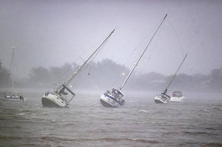
Hurricane Ian was one of the deadliest and most devastating storms to strike the state of Florida. Ian made landfall in Cayo Costa, Florida as a Category 4 hurricane on September 28th, 2022, bringing extreme winds, heavy rainfall, and record storm surges to Southwest Florida. Impacts from Ian were widespread throughout western Cuba and the southeastern United States.
CHNEP's Response
Week One
-
Reached out to check on safety of partners and offer support.
-
Coordinated with University of Florida-Center for Coastal Solutions (UF CCS) to bring in additional personnel to help with post-Ian water quality sampling efforts.
-
Created spreadsheet to coordinate sampling efforts between multiple partners and stakeholders.
-
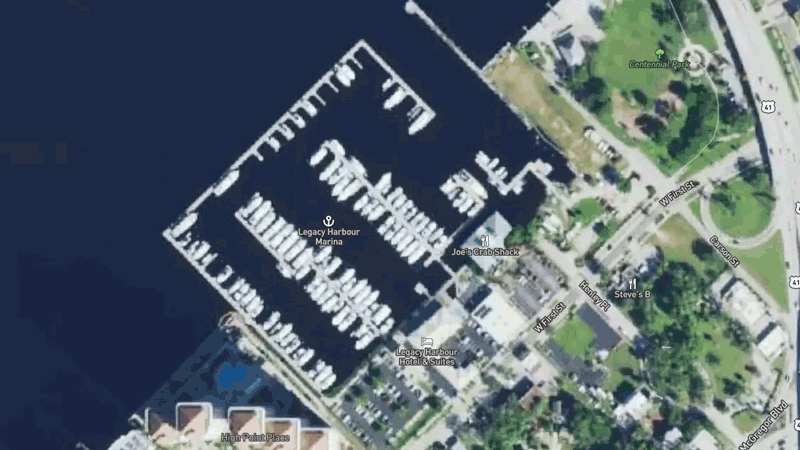
Staff collected samples in Lemon Bay and Charlotte Harbor to gather information on pollution levels and the impacts that Hurricane Ian is having on water quality.
-
Water samples were also collected for lab analysis.
-
Staff participated in weekly meetings with partners to coordinate sampling efforts.
Week Two
-
Lined up external partners to underwrite portions of the sampling costs.
-
Funded ongoing as well as post-Ian sampling efforts directly.
Week Three
-
Staff collected samples in the Caloosahatchee, Matlacha Pass, and Pine Island Sound.
-
Funded online dashboard with partner data compiled.
Week Four and Beyond
-
CHNEP continues to participate in weekly calls to discuss sampling results and findings with all partners involved.
-
Working with partners to conduct preliminary data analysis.
-
Coordinating efforts for future disaster response plans.


Impacts on CHNEP's Estuaries and Rivers
(click on titles in tabs going right for other areas)
Dona & Roberts Bays Basin
-
The Dona and Roberts Bays connects one of the five major watersheds in Sarasota County to the Gulf via the Venice Inlet. Significant features within this basin include Dona Bay, Roberts Bay, Cow Pen Slough, and the Pinelands Reserve and Heritage Ranch Gopher Tortoise Preserve. This basin was historically altered in the 1960s and 1970s through the channelization of Cow Pen Slough which dramatically increased the size of the basin, and increased volumes of freshwater to the downstream estuaries.
-
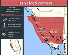
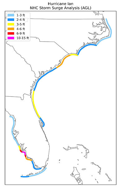
The heavy storm surge was estimated around 6-12 ft, worsened by hours of pounding rainfall across the State of Florida, leading to deep inland flooding.
-
Dona and Roberts Bays received 6-15 inches of rainfall from Hurricane Ian, combined with 80-100 mph winds.

Roberts Bay on Sept. 28. Photo: Pedro Portal/El Nuevo Herald/Tribune News Service via Getty Images


Partners
The Regional Post-Ian Water Quality Sampling Effort includes Charlotte County; Florida Government; Lee County Government; University of Florida Center for Coastal Solutions (UF CCS); Southwest Florida Water Management District (SWFWMD); South Florida Water Management District (SFWMD); Environmental Science Associates (ESA); Florida Department of Environmental Protection (FDEP); Florida Fish and Wildlife Conservation Commission (FWC); Sanibel-Captiva Conservation Foundation (SCCF); Sarasota Bay Estuary Program (SBEP); Florida Gulf Coast University (FGCU); University of South Florida (USF); Florida Sea Grant Charlotte County; National Oceanic and Atmospheric Administration (NOAA); and more!
The Major Hurricane Ian Report is now available from the National Hurricane Center. Click on the image below to view the report. The report features data from the USGS Flood Event Viewer.


Storm Track and Timeline
9/23 - Tropical Depression Nine forms.
9/24 - Upgraded to Tropical Storm Ian with sustained winds > 40 mph.
9/26 - Upgraded to Hurricane Ian with sustained winds of 75 mph.
9/27 - Ian becomes Major Cat 3 Hurricane.
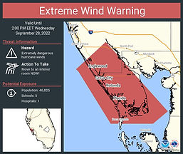
9/28 - Upgraded to Cat 4 Hurricane with max sustained winds of 155 mph.
9/28 - Major Hurricane Ian makes landfall near Cayo Costa, Florida.
9/28 - Second landfall near Punta Gorda, Florida.
9/29 - Downgraded to Tropical Storm with sustained winds of 65 mph near Orlando, FL.
Hurricane Ian made landfall in the exact same location as Hurricane Charley in 2004. Ian was much larger than Charley and its hurricane and tropical-storm force winds were more widespread. In fact, Charley’s wind field could fit within the eye of Hurricane Ian. This caused greater storm surge with Ian, more than double the peak surge from Charley in Fort Myers. Ian also moved slower than Charley causing impacts to last longer and rainfall totals to be more than double those from Charley.

Ian 2022 vs. Charley 2004
Rainfall, Wind, and Surge
Recorded Precipitation by County
Manatee County
-
Myakka City: 15.87"
Sarasota County
-
North Port: 27.7"
-
Venice: 18.16"
Charlotte County
-
Port Charlotte: 23.0"
-
Rotonda: 26.95"
Polk County
-
Winter Haven: 9.5"
-
Lake Wales: 16.99"
Hardee County
-
Wauchula: 12.24"
-
Bowling Green: 12.24"
Glades County
-
Moore Haven: 3.86"
Lee County
-
Lehigh Acres: 14.42"
-
Fort Myers: 9.39"
Highlands County
-
Sebring: 15.0"
DeSoto County
-
Arcadia: 12.83"
The City of Winter Haven received 9.5 inches of rain during Ian. When paired with extreme amounts of rainfall during the months of August and September (13.3 in & 17.4 in, respectively), this resulted in an intense rise in surface levels.
Just after Hurricane Ian, the elevation of the Winter Haven lakes rose to nearly the highest levels recorded since the hurricane season of 2004.

Wind

A tornado occurred in Moore Haven in Glades County. It traveled 1.7 miles with a peak wind speed of 85 mph and was rated an EF-0.


Storm Surge

Unprecedented inundation and damaging flooding due to storm surge was reported throughout Southwest and Central Florida, including record-breaking high water levels in the Myakka, Peace, and Caloosahatchee Rivers.
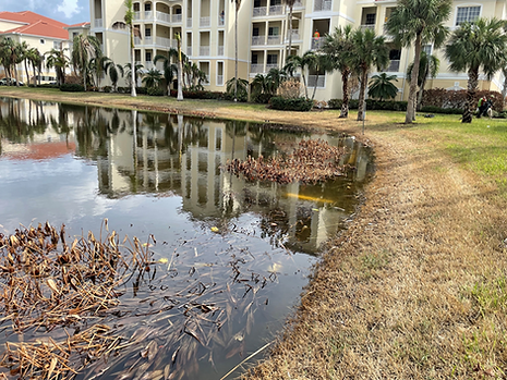
Storm surge of up to 18 ft was reported in Lee County. Saltwater flooding due to storm surge left freshwater lakes and ponds with salinity levels too high to support native vegetation and wildlife.
Native pond vegetation including Pickerel Weed, Duck Potato, and Giant Leather Fern are not able to survive at high salinities.
Several local wildlife species are also dependent on freshwater. The native pig frog and southern leopard frog spend most of their time in freshwater. According to SCCF, these frogs still have not been documented as existing post-Ian.

Credit: Sanibel-Captiva Conservation Foundation

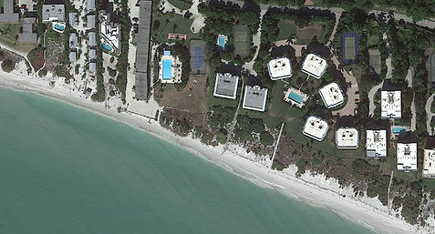
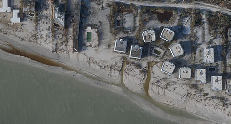
Sanibel View Condominiums

Before
After
Credit: Ernesto Lasso de la Vega
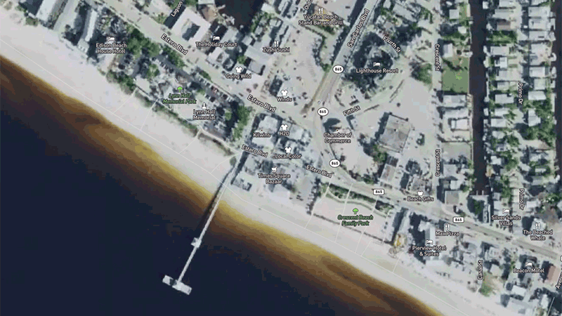
The surge eroded much of the beaches and dunes and left large deep scours in the sand where beach access paths used to be.
Casa Ybel Beach Resort, Sanibel Island
Before
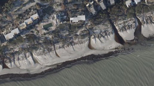
After
Credit: NOAA/NHC
Credit: NOAA
Sanibel Island
Before
After
Credit: USGS
The Aftermath of Hurricane Ian
Runoff Pollution
Unprecedented amounts of every type of pollution were discharged down all rivers in Central and Southwest Florida into our bays and the Gulf of Mexico. This includes solid waste and physical debris from cars and boats, as well as chemical, nutrient and bacteria pollution. The path of the hurricane went right up the Peace River Basin into central Florida, through a 1.3 million acre area referred to as "Bone Valley" where Florida's phosphates are mined to make fertilizer. Many areas were without functioning sewer systems and septic tanks failed and overflowed into the streets.


Red Tide
Nutrient pollution in runoff can stimulate or exacerbate harmful algal blooms. By late October, red tide was present at high concentrations, causing respiratory irritation for residents in Charlotte, Lee and Sarasota counties.
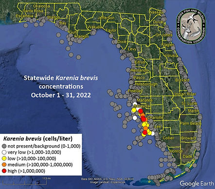

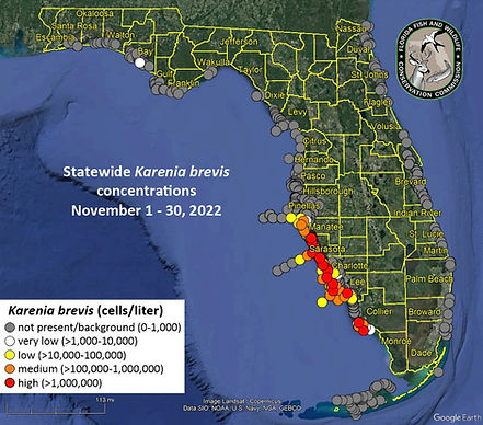

Lighthouse Beach Park in Sanibel on October 10, 2022. Photo Credit: SCCF
Water Quality
As flood and stormwater drained from the landscape, salinities in our estuaries and the Gulf were stratified, with fresh to brackish water layered on top of saltwater. High BOD and hypoxic (low oxygen) conditions were present and appeared to persist for several weeks. Fecal coliform, enterococci, and other bacteria levels were alarmingly high and exceeded well above the threshold for impairment.
The subsequent red tide bloom may have been triggered or exacerbated by nutrient plumes associated with the hurricane. All of these factors working together led to mass fish die-offs throughout CHNEP estuaries and inland lakes.
Mangrove Mortality
Post-Hurricane Ian HiForm forest NDVI change analysis available at
https://hiform.org/projects/2022-hurricane-ian.

Map provided by the Eastern Forest Environmental Threat Assessment Center, USDA Forest Service
Recovery
Ian blew an enormous amount of debris into our rivers and estuaries including styrofoam and metal debris from roofs. CHNEP partnered with Sarasota Bay Watch, Suncoast Waterkeeper, Suncoast Aqua Ventures, and Lemon Bay Conservancy to sponsor a cleanup in the canals of Ainger Creek, major tributary of the Lemon Bay watershed. Holiday Estates, the community that surrounds the canals, was devastated by the storm. Debris that could not be collected was geotagged and sent to Charlotte County for professional removal.
The photos and videos below show styrofoam and other debris in the Holiday Estates community canals as well as along the Myakka River from aerial surveys funded through Sarasota County WCIND Waterway Development Program grants.

Map of debris areas along the Myakka River including the Harbor Cove community, Lazy River Village, and Venice Myakka RV Resort
Video Credit: Tom Fastiggi & John Ryan

Holiday Estates
Ainger Creek Canals - Lemon Bay
Credit: Sarasota Bay Watch
The styrofoam is breaking down into smaller pieces, making it harder to retrieve and more of a hazard to wildlife. Sarasota Bay Watch recently held debris cleanup events in the Harbor Cove community in North Port, which gathered volunteers to remove trash and restore the Wild & Scenic Myakka River. Sarasota Bay Watch says 150 volunteers helped fill five 40-yard dumpsters and three 16-yard dumpsters with debris from the river and its canals at the first cleanup held in February.
Much progress has been made to remove trash along the Myakka River. Still, there is a large amount of styrofoam and metal debris that persists. The video below shows the Myakka River in March 2023 following the cleanup events.
Charlotte County
Lee County
Don't see information on recovery efforts in your county? Check out the links below for more storm recovery updates throughout the CHNEP area!
DIY Recovery
Download the SCCF Replanting Guide to learn best practices for native planting and support resiliency in your yard and landscapes in the future!

Lessons Learned
Problems encountered related to Water Quality included:
-
Surface water can be impacted by not only by nutrient and contaminant concerns from runoff (gas, oil, pesticides, physical debris) but also elevated bacteria levels from septic and sewer overflows as well as the risk posed by some algae blooms or other natural occurring organisms such as Vibrio being given ideal conditions to proliferate post-storm.
-
Currently surface water is seen as environmental only, not a public health concern in the way that drinking water may be. Providing information on surface water quality not included in emergency management protocols/practices.
-
Up to date information on water quality concerns for policy makers and the public as it can also have impacts to human health and post-storm practices.
Potential Next Steps
-
Need to better integrate water quality monitoring and emergency operations. Educate emergency mangers/Policy makers on the impact water quality has to human, ecologic, and economic health after a major storm event and the need to have a coordinated response plan. Educate environmental managers on EOC processes and procedures.
-
Increase 'nimbleness' of response time and identify where and how collected data will be shared.
Future Implications
More available energy from increased ocean temperatures and increased atmospheric moisture will cause winds in the strongest storms to become stronger, meaning wind damages would be greater and storm surge would be larger.
Using the same attribution technique recently peer-reviewed in Nature Communications, preliminary analysis by Prof. Kevin Reed and Michael Wehner shows human-driven changes increased Ian’s extreme rain rates by over 10%.
More specifically, accumulated precipitation over land during Hurricane Ian increased by 15.3 to 20.7%, leaving 500,000 more people flooded.

Billions of dollars worth of damage to coastal property is caused each year by hurricanes and cyclones that produce storm surges. However, the presence of mangroves has shown to reduce flood depths during tropical cyclones, thereby reducing flood damages to people and their property, especially landward property.
The economic damages in Florida from storm surges alone were approximately $13 billion during Hurricane Ian. The complete absence of present-day mangroves would have increased damages by an estimated $4.1 billion. However, the presence of mangroves reduced flood depths by over a meter in several coastal regions of Collier, Lee, and Charlotte Counties during Ian.
The approximately 250 square kilometers of mangroves in Collier County reduce annual losses from storm surge by $67 million.

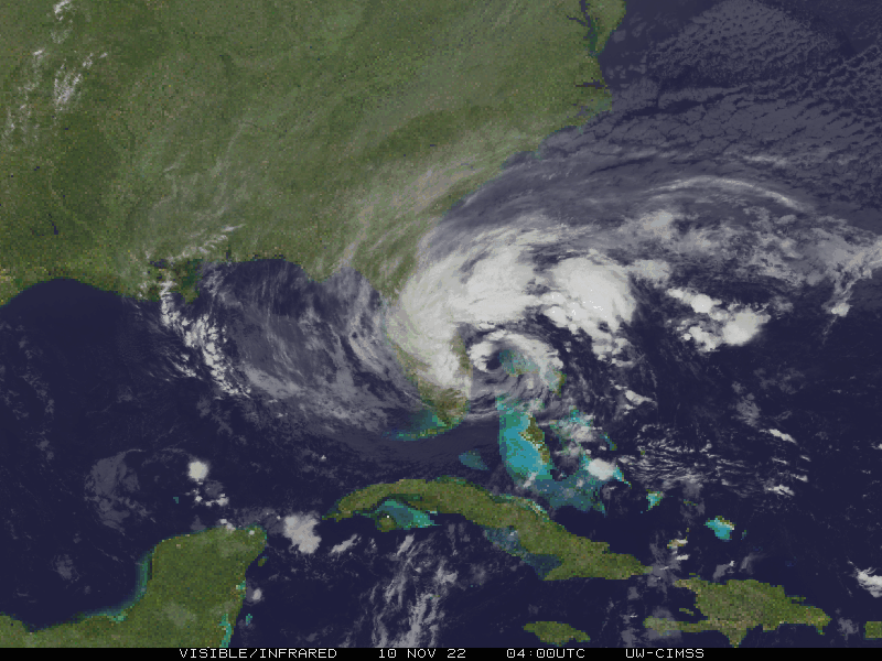
On the heels of Ian came a record-breaking November Hurricane. Hurricane Nicole was only the third November hurricane to hit Florida, making landfall in Florida on November 10, 2022. Nicole also holds the record for the second-highest surge above sea level.
The shortened recovery time between storms reduces resiliency.
Video Presentations
Hurricane Ian Recovery Discussion with the Federal Interagency Recovery Coordination (IRC) Team
Hurricane Ian - Michael Wehner, Lawrence Berkeley National Laboratory
Post Hurricane Ian Water Quality Dashboard - Dr. Miles Medina, UF Center for Coastal Solutions
2023 Southwest Florida Climate Summit - Session on Hurricane Ian
At the CHNEP Management Conference meetings of the Management and Policy Committees held in 2023, the federal Interagency Recovery Coordination (IRC) team came to directly hear CHNEP member comments about how the federal government could assist Hurricane Ian Recovery Efforts.
CHNEP synthesized the Committees' comments and worked with the IRC to gather their written responses to these identified recovery needs. These responses, as well as contact information for members to personally follow up with the IRC, are available in a document that has been posted here.
Please feel free to share this document widely with natural resource managers, emergency managers and any others who might be able to use the information contained herein to further recovery and resiliency efforts in our region. The IRC has since met with CHNEP Committees and partners about Hurricanes Milton & Helene.
